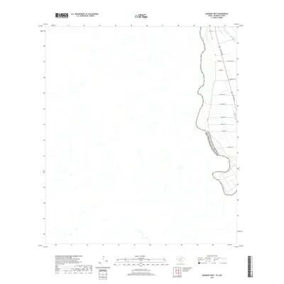
2019 Map of Quemado West
USGS Topo · Published 2019About this map
The Rio Grande serves as the prominent natural boundary in this border region, separating the United States of America from the Estados Unidos Mexicanos. Along the eastern bank in Maverick County, a developing grid of rural residential and agricultural roads extends from Del Rio Blvd, the primary corridor through the area. Local naming conventions are evident in family-linked labels such as Pendergrass Rd, Rizley Rd, and Willory Farm Rd, suggesting the historical agricultural roots and property divisions of the late 20th and early 21st centuries. The landscape transitions from these organized road networks near Fm 1664 and Moore Ave W to the winding river topography that defines the international frontier.
Find a feature on this map
17 named features on this map. Tap any name to fly to it.
Don’t see what you’re looking for? This feature index may not catch every label — zoom into the map to look around manually.
Map Details
Editions of this 2019 Quemado West Map
This is the sole edition of this map. No revisions or reprints were ever made.
Other maps of this area

1940 · Quemado
USGS Topo · 1:62,500

1941 · Tequesquite Creek
USGS Topo · 1:62,500

1944 · Sycamore Ranch
USGS Topo · 1:62,500

1944 · Tequesquite Creek
USGS Topo · 1:62,500

1958 · Eagle Pass
USGS Topo · 1:250,000

1958 · Del Rio
USGS Topo · 1:250,000

1964 · Del Rio
USGS Topo · 1:250,000

1965 · Eagle Pass
USGS Topo · 1:250,000
1974 · Quemado SE
USGS Topo · 1:24,000
1978 · Tequesquite Spring
USGS Topo · 1:24,000