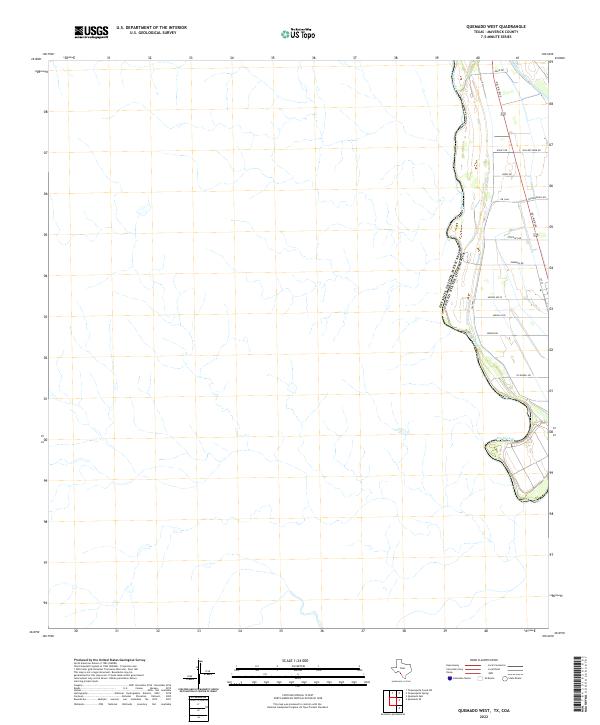
2022 Map of Quemado West
USGS Topo · Published 2022About this map
The Rio Grande forms a prominent meandering border along the western edge of this Maverick County landscape, delineating the international boundary between Estados Unidos Mexicanos and the United States of America. To the east, a sparse network of rural roads reveals the agricultural and residential character of the region. Primary transit is handled by Del Rio Blvd and Fm 1664, which serve as the backbone for numerous smaller lanes. Many of these thoroughfares, such as Willory Farm Rd, O'Connell Rd, and Pendergrass Rd, appear to be named for local families or farms, offering specific points of interest for genealogists tracing regional land ownership. The terrain between these roads and the river is characterized by numerous small drainage features and dry washes that eventually feed into the larger river system, reflecting the arid environment of West Texas.
Find a feature on this map
16 named features on this map. Tap any name to fly to it.
Don’t see what you’re looking for? This feature index may not catch every label — zoom into the map to look around manually.
Map Details
Editions of this 2022 Quemado West Map
This is the sole edition of this map. No revisions or reprints were ever made.
Other maps of this area

1940 · Quemado
USGS Topo · 1:62,500

1941 · Tequesquite Creek
USGS Topo · 1:62,500

1944 · Sycamore Ranch
USGS Topo · 1:62,500

1944 · Tequesquite Creek
USGS Topo · 1:62,500

1958 · Eagle Pass
USGS Topo · 1:250,000

1958 · Del Rio
USGS Topo · 1:250,000

1964 · Del Rio
USGS Topo · 1:250,000

1965 · Eagle Pass
USGS Topo · 1:250,000
1974 · Quemado SE
USGS Topo · 1:24,000
1978 · Tequesquite Spring
USGS Topo · 1:24,000