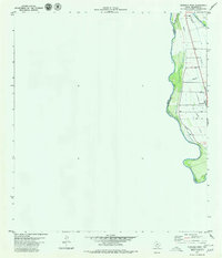
1979 Map of Quemado West
USGS Topo · Published 1979About this map
Rio Grande waters define the international border in the late 1970s, where the Mexico United States boundary follows the winding river course along the western edge of Maverick County. This arid landscape is shaped by the Maverick County Canal, which provides vital irrigation parallel to the river. The small settlement of Quemado serves as the local hub, situated near the intersection of various unimproved roads and an irrigation network. Evidence of energy extraction appears in the north with several Oil Wells, while a prominent Radio Tower stands near the town center. The map details the transition from the riparian zone at the riverbank to the interior plains, marked by numerous Wells and local drainage features like Las Moras Creek.
Find a feature on this map
10 named features on this map. Tap any name to fly to it.
Don’t see what you’re looking for? This feature index may not catch every label — zoom into the map to look around manually.
Map Details
Editions of this 1979 Quemado West Map
This is the sole edition of this map. No revisions or reprints were ever made.
Other maps of this area

1940 · Quemado
USGS Topo · 1:62,500

1941 · Tequesquite Creek
USGS Topo · 1:62,500

1944 · Sycamore Ranch
USGS Topo · 1:62,500

1944 · Tequesquite Creek
USGS Topo · 1:62,500

1958 · Eagle Pass
USGS Topo · 1:250,000

1958 · Del Rio
USGS Topo · 1:250,000

1964 · Del Rio
USGS Topo · 1:250,000

1965 · Eagle Pass
USGS Topo · 1:250,000
1974 · Quemado SE
USGS Topo · 1:24,000
1978 · Tequesquite Spring
USGS Topo · 1:24,000