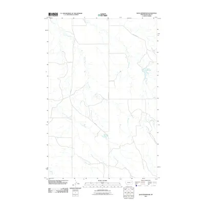
2011 Map of Quick Reservoir
USGS Topo · Published 2011About this map
Quick Reservoir and Mccluys Reservoir anchor this McCone County landscape, highlighting the essential role of water management in eastern Montana. The terrain is defined by a network of seasonal drainages, including the prominent McCune Creek and Hell Creek, which carve through the high plains. Significant topographical points like Circle Tower Hl overlook the winding Dry Ash Creek and the drainage known as Deep Bottom. Human infrastructure is sparse, limited to arterial corridors such as Union Rd and McCune Creek Rd that navigate the ridges and valleys between these water sources. This survey captures a rural ranching environment where the placement of stock reservoirs and the names of local coulees reflect the community's reliance on and adaptation to the arid prairie geography.
Find a feature on this map
10 named features on this map. Tap any name to fly to it.
Don’t see what you’re looking for? This feature index may not catch every label — zoom into the map to look around manually.
Map Details
Editions of this 2011 Quick Reservoir Map
This is the sole edition of this map. No revisions or reprints were ever made.
Other maps of this area

1954 · Glendive
USGS Topo · 1:250,000

1957 · Glendive
USGS Topo · 1:250,000

1958 · Glendive
USGS Topo · 1:250,000

1982 · Circle
USGS Topo · 1:100,000

1983 · Youngquist Mine
USGS Topo · 1:24,000

1983 · Woodworth Hill
USGS Topo · 1:24,000

1983 · Mount Antelope
USGS Topo · 1:24,000

1983 · Quick Reservoir
USGS Topo · 1:24,000

1983 · Circle
USGS Topo · 1:24,000
1983 · Bearshack Creek
USGS Topo · 1:24,000