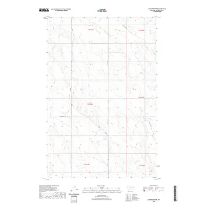
2020 Map of Quick Reservoir
USGS Topo · Published 2020About this map
Quick Reservoir and Mcclays Reservoir are the primary water management features in this arid reach of McCone County. This modern topographic study reveals a landscape defined by intermittent drainage systems, including the branched paths of Hell Cr and McCune Cr, which carve into the terrain. The presence of Deep Bottom suggests the natural erosion patterns common to this part of the Montana plains. Transportation in the region is facilitated by a network of rural routes such as Union Rd, Heide Rd, and Brockway East Rd, which link remote grazing or agricultural lands. The map illustrates how human infrastructure like the Circle Tower Hill road and various reservoir systems have been integrated into the natural coulees and creek beds like Dry Ash Cr.
Find a feature on this map
18 named features on this map. Tap any name to fly to it.
Don’t see what you’re looking for? This feature index may not catch every label — zoom into the map to look around manually.
Map Details
Editions of this 2020 Quick Reservoir Map
This is the sole edition of this map. No revisions or reprints were ever made.
Other maps of this area

1954 · Glendive
USGS Topo · 1:250,000

1957 · Glendive
USGS Topo · 1:250,000

1958 · Glendive
USGS Topo · 1:250,000

1982 · Circle
USGS Topo · 1:100,000

1983 · Youngquist Mine
USGS Topo · 1:24,000

1983 · Woodworth Hill
USGS Topo · 1:24,000

1983 · Mount Antelope
USGS Topo · 1:24,000

1983 · Quick Reservoir
USGS Topo · 1:24,000

1983 · Circle
USGS Topo · 1:24,000
1983 · Bearshack Creek
USGS Topo · 1:24,000