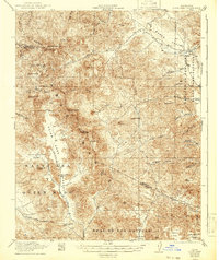
1922 Map of Quien Sabe
USGS Topo · Published 1942About this map
The Diablo Range dominates this landscape on the border of Merced and San Benito counties, reflecting a period when remote mountain ranching and small-scale mining defined the region. Much of the activity is centered in the Quien Sabe Valley, where the Quien Sabe School and Quien Sabe Creek served a scattered community of landholders. To the south, the Buena Vista Ranch sits near the headwaters of Santa Ana Creek, while the northern reaches transition into the Los Banos Valley. The map records the industrial footprint of the Stayton Mine and Antimony Pk, indicating the area's mineral importance during the early 20th century. High peaks like Mariposa Pk and Laveaga Pk overlook a complex network of canyons, including Ruby Canyon and Buckeye Canyon, and the high-elevation pastures of Dairy Flat within the Real De Las Aguilas grant.
Find a feature on this map
49 named features on this map. Tap any name to fly to it.
Don’t see what you’re looking for? This feature index may not catch every label — zoom into the map to look around manually.
Map Details
Editions of this 1922 Quien Sabe Map
4 editions found
Other maps of this area

1913 · Panoche
USGS Topo · 1:125,000

1919 · San Benito
USGS Topo · 1:62,500

1919 · Hollister
USGS Topo · 1:48,000

1920 · Pacheco Pass
USGS Topo · 1:62,500

1920 · Carrisalito Spring
USGS Topo · 1:31,680

1921 · Volta
USGS Topo · 1:31,680

1921 · Gonzales
USGS Topo · 1:62,500

1921 · Gilroy Hot Springs
USGS Topo · 1:62,500

1921 · Hollister
USGS Topo · 1:62,500

1922 · Quien Sabe
USGS Topo · 1:62,500