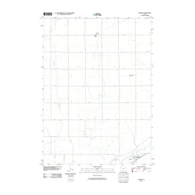
2010 Map of Quimby
USGS Topo · Published 2010About this map
Quimby sits along the southern bank of the Little Sioux River in this 2010 survey of Cherokee County. The map documents the rural organization of the surrounding prairie, where a grid of numbered roads like 580th St and lettered avenues connect the isolated settlement of Mary Hill to the river valley. Local history is anchored by the Mary Hill Cemetery and Rock Township Cemetery, which serve as quiet markers of the region's agricultural heritage. The landscape is defined by the drainage patterns of Rock Creek and Willow Creek as they flow toward the main river channel. In town, the Quimby Post Office and Quimby Golf Course represent the community's modern civic and recreational footprint. The transition from the high, gridded farmland to the winding river bottom highlights the enduring relationship between the local geography and the rural Iowa road system.
Find a feature on this map
25 named features on this map. Tap any name to fly to it.
Don’t see what you’re looking for? This feature index may not catch every label — zoom into the map to look around manually.
Map Details
Editions of this 2010 Quimby Map
This is the sole edition of this map. No revisions or reprints were ever made.
Other maps of this area

1954 · Fort Dodge
USGS Topo · 1:250,000

1957 · Fort Dodge
USGS Topo · 1:250,000

1958 · Fort Dodge
USGS Topo · 1:250,000

1969 · Pierson
USGS Topo · 1:24,000

1969 · Cleghorn
USGS Topo · 1:24,000

1969 · Fielding
USGS Topo · 1:24,000
1969 · Marcus
USGS Topo · 1:24,000

1969 · Cherokee South
USGS Topo · 1:24,000

1969 · Quimby SE
USGS Topo · 1:24,000
1969 · Washta
USGS Topo · 1:24,000