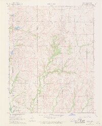
1968 Map of Quincy
USGS Topo · Published 1969About this map
Quincy serves as the primary settlement hub within this landscape, situated near the southwestern edge of the Woodson County line. The topography is heavily influenced by the presence of the Toronto Reservoir, which dominates the lower portion of the quadrangle. As the Verdigris R enters this impoundment, it creates a complex system of inlets and drainages, most notably where Dry Creek and Turkey Creek feed into the reservoir basin. This mid-century survey captures the region's rural character, where early petroleum extraction is evidenced by scattered Oil Wells across the northern sections.
Find a feature on this map
14 named features on this map. Tap any name to fly to it.
Don’t see what you’re looking for? This feature index may not catch every label — zoom into the map to look around manually.
Map Details
Editions of this 1968 Quincy Map
This is the sole edition of this map. No revisions or reprints were ever made.
Other maps of this area

1885 · Burlington
USGS Topo · 1:125,000

1885 · Eureka
USGS Topo · 1:125,000

1886 · Fredonia
USGS Topo · 1:125,000

1888 · Emporia
USGS Topo · 1:125,000

1888 · Eureka
USGS Topo · 1:125,000

1894 · Emporia
USGS Topo · 1:125,000

1894 · Fredonia
USGS Topo · 1:125,000

1894 · Burlington
USGS Topo · 1:125,000

1894 · Eureka
USGS Topo · 1:125,000

1947 · Lawrence
USGS Topo · 1:250,000