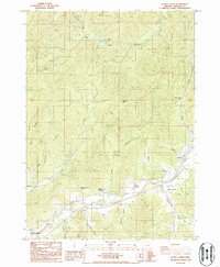
1986 Map of Quines Creek
USGS Topo · Published 1986About this map
Cow Creek and the southern flow of Quines Creek define the settlement pattern of this Douglas County landscape during the mid-1980s. The community of Azalea serves as a local hub near the confluence of several mountain branches, while small clusters at Galesville and Fernvale reflect the dispersed rural character of the area. Significant local history markers include a Cem and Schoolhouse Spring, which point to earlier generations of residents who established homes along the creek bottoms. The terrain is dominated by prominent ridges and peaks, most notably Buckhorn Mtn and the curious landmark of Horse Heaven. Mapping of numerous extraction sites, including a Rock Quarry and several Borrow Pit locations, suggests ongoing road maintenance or industrial activity typical of Oregon's timber and transit corridors during this era. Public spaces like Windy Creek County Park provide a glimpse into the regional recreational land use established by the late twentieth century.
Find a feature on this map
40 named features on this map. Tap any name to fly to it.
Don’t see what you’re looking for? This feature index may not catch every label — zoom into the map to look around manually.
Map Details
Editions of this 1986 Quines Creek Map
This is the sole edition of this map. No revisions or reprints were ever made.
Other maps of this area

1904 · Riddle
USGS Topo · 1:125,000

1954 · Days Creek
USGS Topo · 1:62,500

1954 · Glendale
USGS Topo · 1:62,500

1954 · Wimer
USGS Topo · 1:62,500

1954 · Canyonville
USGS Topo · 1:62,500

1955 · Medford
USGS Topo · 1:250,000

1957 · Medford
USGS Topo · 1:250,000

1958 · Medford
USGS Topo · 1:250,000
1983 · King Mountain
USGS Topo · 1:24,000
1986 · Glendale
USGS Topo · 1:24,000