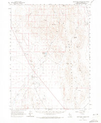
1961 Map of Quinn River Crossing
USGS Topo · Published 1972About this map
Quinn River Crossing stands as a focal point in this high-desert basin, where the Quinn River meanders through the valley floor. The map documents a critical nexus of water and travel, featuring numerous springs and wells such as Paine Well and Hay Quinn River Well that supported livestock and passage through the arid terrain. To the east, the Black Rock Range and Black Mtn dominate the horizon, while the Jackson Mountains rise to the south. This 1960s landscape is defined by its transit routes, including the Old Winnemucca Road and Ninemile Road, which connect remote outposts like the Nine Mile Ranch. The presence of the Bilk Creek Reservoir and various gravel pits suggests the local importance of water management and early infrastructure development in Humboldt County during this era.
Find a feature on this map
37 named features on this map. Tap any name to fly to it.
Don’t see what you’re looking for? This feature index may not catch every label — zoom into the map to look around manually.
Map Details
Editions of this 1961 Quinn River Crossing Map
2 editions found
Other maps of this area

1886 · Disaster
USGS Topo · 1:250,000

1893 · Disaster
USGS Topo · 1:250,000

1954 · Vya
USGS Topo · 1:250,000

1958 · Vya
USGS Topo · 1:250,000

1961 · Quinn River Crossing
USGS Topo · 1:62,500

1961 · Thacker Pass
USGS Topo · 1:62,500

1961 · Trident Peak
USGS Topo · 1:62,500

1961 · Bottle Creek
USGS Topo · 1:62,500

1961 · Disaster Peak
USGS Topo · 1:62,500

1962 · Vya
USGS Topo · 1:250,000