
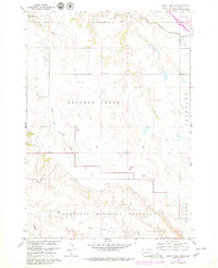
1960 Map of Quinn Table NE
USGS Topo · Published 1961About this map
Badlands National Monument dominates the southern landscape of this 1960 survey, where the eroded breaks and complex topography drop away from the higher elevations of the north. The area is defined by the drainage systems of South Fork Crooked Creek and Sage Creek, which carve into the terrain below Lake Flat. A significant stretch of the Chicago and North Western railroad cuts across the northeastern corner, tracing a path near a small Landing Field. Rural infrastructure of the era is evident through the presence of the North Star Sch and a Microwave Tower, illustrating the sparse but organized settlement pattern of Pennington County during the mid-century development of the Missouri River Basin. The map also records the official Base Line and localized place names like Fairview, capturing the transition from agricultural tablelands to the protected monument boundaries.
Find a feature on this map
11 named features on this map. Tap any name to fly to it.
Don’t see what you’re looking for? This feature index may not catch every label — zoom into the map to look around manually.
Map Details
Editions of this 1960 Quinn Table NE Map
2 editions found
Other maps of this area

1953 · Rapid City
USGS Topo · 1:250,000

1954 · Wasta SE
USGS Topo · 1:24,000

1954 · Wasta
USGS Topo · 1:24,000

1954 · Quinn Table
USGS Topo · 1:24,000

1955 · Hot Springs
USGS Topo · 1:250,000

1957 · Rapid City
USGS Topo · 1:250,000

1960 · Wall
USGS Topo · 1:24,000

1960 · Quinn Table SE
USGS Topo · 1:24,000
1960 · Wall SW
USGS Topo · 1:24,000
1960 · Quinn Table SW
USGS Topo · 1:24,000