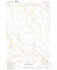
1960 Map of Quinn Table NE
USGS Topo · Published 1979About this map
Badlands National Monument defines the southern portion of this landscape, where the sharp topography of the badlands meets the more level terrain of Lake Flat to the north. Surveyed in 1960 with revisions through 1979, the map illustrates a sparsely populated region of Pennington County centered on the drainages of South Fork Crooked Creek and Sage Creek. Cultural landmarks reflect the isolation and utility of the era, including the North Star Sch, a Microwave Tower, and a remote Landing Field in the northeast corner near the Chicago and North Western railroad line. The map provides a clear look at the transitional environment between the dramatic erosion of the Conata area and the managed ranch lands of Wasta, offering essential detail for researchers studying mid-century land use and government boundaries in western South Dakota.
Find a feature on this map
13 named features on this map. Tap any name to fly to it.
Don’t see what you’re looking for? This feature index may not catch every label — zoom into the map to look around manually.
Map Details
Editions of this 1960 Quinn Table NE Map
2 editions found
Other maps of this area

1953 · Rapid City
USGS Topo · 1:250,000

1954 · Wasta SE
USGS Topo · 1:24,000

1954 · Wasta
USGS Topo · 1:24,000

1954 · Quinn Table
USGS Topo · 1:24,000

1955 · Hot Springs
USGS Topo · 1:250,000

1957 · Rapid City
USGS Topo · 1:250,000

1960 · Quinn Table NE
USGS Topo · 1:24,000

1960 · Wall
USGS Topo · 1:24,000

1960 · Quinn Table SE
USGS Topo · 1:24,000
1960 · Wall SW
USGS Topo · 1:24,000