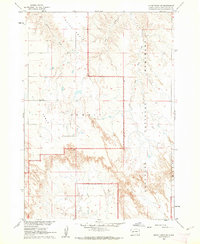
1960 Map of Quinn Table SW
USGS Topo · Published 1962About this map
Badlands National Monument dominates the southern and eastern stretches of this South Dakota landscape, where the dramatic erosion of the Great Plains is captured in intricate contour. The plateau known as Quinn Table extends across the northern reaches, providing a stark contrast to the deeply dissected drainages of Beaver Creek and Dry Creek. This 1960 field-checked survey was conducted as part of the Department of the Interior program for the development of the Missouri River Basin, documenting the sparse infrastructure of Pennington County during the mid-century. Human activity is localized to features like the Jobgen Sch and a Gravel Pit near the headwaters of South Fork Sage Creek. The transition from the flat expanse of Scenic Table into the complex breaks of the badlands illustrates the unique geological character of this region before modern developments.
Find a feature on this map
8 named features on this map. Tap any name to fly to it.
Don’t see what you’re looking for? This feature index may not catch every label — zoom into the map to look around manually.
Map Details
Editions of this 1960 Quinn Table SW Map
2 editions found
Other maps of this area

1950 · Sheep Mountain Table
USGS Topo · 1:24,000

1950 · Imlay
USGS Topo · 1:24,000

1950 · Bouquet Table
USGS Topo · 1:24,000

1952 · Bouquet Table
USGS Topo · 1:24,000

1954 · Scenic
USGS Topo · 1:24,000

1954 · Brennan Flat
USGS Topo · 1:24,000

1954 · Quinn Table
USGS Topo · 1:24,000

1955 · Hot Springs
USGS Topo · 1:250,000

1960 · Quinn Table NE
USGS Topo · 1:24,000

1960 · Quinn Table SE
USGS Topo · 1:24,000