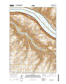
2014 Map of Quinton
USGS Topo · Published 2014About this map
The Columbia River defines the border between Washington and Oregon in this 2014 survey, where the waters of Lake Umatilla dominate the river valley. The settlement of Goodnoe sits on the northern bank, while the site of Quinton marks a point along the bend where the Wa-14 highway traverses the shoreline. The landscape is deeply incised by significant drainage systems, notably the John Day River which snakes through the southern portion of the quadrangle, flanked by numerous topographical features such as Biglow Canyon and Emigrant Canyon.
Find a feature on this map
34 named features on this map. Tap any name to fly to it.
Don’t see what you’re looking for? This feature index may not catch every label — zoom into the map to look around manually.
Map Details
Editions of this 2014 Quinton Map
This is the sole edition of this map. No revisions or reprints were ever made.
Other maps of this area

1916 · Arlington
USGS Topo · 1:125,000

1953 · The Dalles
USGS Topo · 1:250,000

1956 · The Dalles
USGS Topo · 1:250,000

1957 · The Dalles
USGS Topo · 1:250,000

1957 · Wasco
USGS Topo · 1:62,500

1957 · Satus Pass
USGS Topo · 1:62,500

1964 · Mc Donald
USGS Topo · 1:24,000

1965 · Goodnoe Hills
USGS Topo · 1:24,000

1971 · Quinton
USGS Topo · 1:24,000
1971 · Sundale NW
USGS Topo · 1:24,000