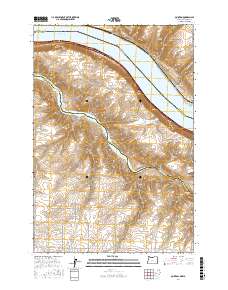
2017 Map of Quinton
USGS Topo · Published 2017About this map
The Columbia River and its confluence with the John Day River form the geographical heart of this Columbia Plateau landscape. This modern survey illustrates the complex boundary where Washington and Oregon meet, featuring the settlements of Goodnoe and Quinton along the northern banks. The presence of Lake Umatilla and Squally Hook Rapids indicates the regulated nature of the river system, while the rugged southern terrain is defined by deep incisions like Biglow Canyon, Emigrant Canyon, and Box Canyon. Local land use is tied to these dramatic elevation changes, with rural roads such as Chamberlain Goodnoe Rd and Fox Rd providing access to the high plateaus above the river gorge. The map also records significant landmarks like Tumwater Falls and the geographic feature known as The Nook, documenting the intersection of Klickitat, Gilliam, and Sherman counties.
Find a feature on this map
29 named features on this map. Tap any name to fly to it.
Don’t see what you’re looking for? This feature index may not catch every label — zoom into the map to look around manually.
Map Details
Editions of this 2017 Quinton Map
This is the sole edition of this map. No revisions or reprints were ever made.
Other maps of this area

1916 · Arlington
USGS Topo · 1:125,000

1953 · The Dalles
USGS Topo · 1:250,000

1956 · The Dalles
USGS Topo · 1:250,000

1957 · The Dalles
USGS Topo · 1:250,000

1957 · Wasco
USGS Topo · 1:62,500

1957 · Satus Pass
USGS Topo · 1:62,500

1964 · Mc Donald
USGS Topo · 1:24,000

1965 · Goodnoe Hills
USGS Topo · 1:24,000

1971 · Quinton
USGS Topo · 1:24,000
1971 · Sundale NW
USGS Topo · 1:24,000