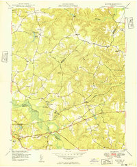
1949 Map of Quinton
USGS Topo · Published 1949About this map
The Chickahominy River serves as a geographic anchor for this post-war landscape, where the borders of Hanover, New Kent, and Henrico counties converge. The area is defined by a series of wetlands and creeks, including Cattail Swamp and Black Creek, which dictated the early road and settlement patterns. Local commerce and community life are grounded in landmarks like Parsleys Mill and small crossroads such as Quinton and Bottoms Bridge.
Find a feature on this map
42 named features on this map. Tap any name to fly to it.
Don’t see what you’re looking for? This feature index may not catch every label — zoom into the map to look around manually.
Map Details
Editions of this 1949 Quinton Map
2 editions found
Other maps of this area

1894 · Bermuda Hundred
USGS Topo · 1:62,500

1894 · Richmond
USGS Topo · 1:62,500

1895 · Richmond
USGS Topo · 1:62,500

1918 · Charles City
USGS Topo · 1:62,500

1920 · King William
USGS Topo · 1:62,500

1934 · Seven Pines
USGS Topo · 1:24,000

1938 · Dutch Gap
USGS Topo · 1:24,000

1938 · Seven Pines
USGS Topo · 1:31,680

1938 · Studley
USGS Topo · 1:31,680

1943 · Dutch Gap
USGS Topo · 1:31,680