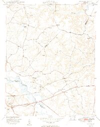
1949 Map of Quinton
USGS Topo · Published 1949About this map
Parsleys Millpond and the headwaters of the Chickahominy River anchor this 1940s landscape where the borders of New Kent, Hanover, and Henrico counties converge. The area is defined by a rural network of small community centers like Quinton, Parsleys, and Bottoms Bridge, largely sustained by small-scale milling operations at sites such as Flanagans Mill. In the south, the Southern railroad runs parallel to the swampy lowland terrain of the river valley, passing through a cluster of civic and spiritual centers including Union Ch and Quinton Sch.
Find a feature on this map
42 named features on this map. Tap any name to fly to it.
Don’t see what you’re looking for? This feature index may not catch every label — zoom into the map to look around manually.
Map Details
Editions of this 1949 Quinton Map
2 editions found
Other maps of this area

1894 · Bermuda Hundred
USGS Topo · 1:62,500

1894 · Richmond
USGS Topo · 1:62,500

1895 · Richmond
USGS Topo · 1:62,500

1918 · Charles City
USGS Topo · 1:62,500

1920 · King William
USGS Topo · 1:62,500

1934 · Seven Pines
USGS Topo · 1:24,000

1938 · Dutch Gap
USGS Topo · 1:24,000

1938 · Seven Pines
USGS Topo · 1:31,680

1938 · Studley
USGS Topo · 1:31,680

1943 · Dutch Gap
USGS Topo · 1:31,680