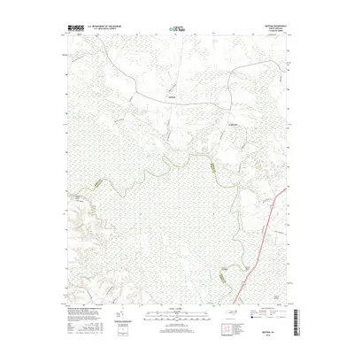
2016 Map of Quitsna
USGS Topo · Published 2016About this map
Quitsna and Grabtown anchor this map of the low-lying river country where the Roanoke River separates Bertie and Martin counties. This landscape is defined by its complex hydrology, dominated by the expansive Roquist Pocosin and dense wetlands like Frog Level Swamp and Town Swamp. The river meanders sharply through the southern half of the sheet, forming distinct features such as Frying Pan Bend and Conine Bend, while Conoho Creek flows through the southwestern reaches. The road network, including Rascoe Club House Rd and Roquist Pocosin Rd, follows the higher ground around the pocosin, reflecting the historical challenge of navigating this saturated terrain. The mapping of Conine Island and various landings suggests a long-standing relationship between these local settlements and the river's winding course.
Find a feature on this map
35 named features on this map. Tap any name to fly to it.
Don’t see what you’re looking for? This feature index may not catch every label — zoom into the map to look around manually.
Map Details
Editions of this 2016 Quitsna Map
This is the sole edition of this map. No revisions or reprints were ever made.
Other maps of this area

1901 · Williamston
USGS Topo · 1:62,500

1902 · Williamston
USGS Topo · 1:62,500

1943 · Plymouth
USGS Topo · 1:125,000

1953 · Norfolk
USGS Topo · 1:250,000

1953 · Rocky Mount
USGS Topo · 1:250,000

1954 · Rocky Mount
USGS Topo · 1:250,000

1972 · Republican
USGS Topo · 1:24,000

1972 · Woodville
USGS Topo · 1:24,000
1978 · Jamesville
USGS Topo · 1:24,000

1978 · Windsor South
USGS Topo · 1:24,000