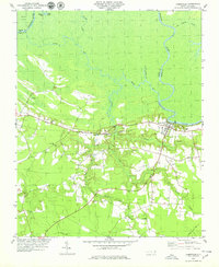
1978 Map of Jamesville
USGS Topo · Published 1979About this map
The Roanoke River dominates this mid-1970s landscape, carving a meandering boundary between Bertie and Martin counties. The intricate waterway system, including the serpentine Devils Gut and Lower Deadwater Creek, defines a low-lying geography where human settlement is concentrated on the slightly higher ground south of the river. The Seaboard Coast Line railroad runs parallel to the river, anchoring the town of Jamesville and the nearby Tar Landing. This region is characterized by its numerous rural congregations, with St James Ch, Siloam Ch, and Fairview Ch serving as community hubs. The map reveals a transition from the swampy river bottoms of Cooper Swamp and Lanier Swamp to more developed uplands where family-named locations like Hardison and Goddard Hill are found along the secondary road networks like Allen Road.
Find a feature on this map
32 named features on this map. Tap any name to fly to it.
Don’t see what you’re looking for? This feature index may not catch every label — zoom into the map to look around manually.
Map Details
Editions of this 1978 Jamesville Map
This is the sole edition of this map. No revisions or reprints were ever made.
Other maps of this area

1901 · Williamston
USGS Topo · 1:62,500

1902 · Williamston
USGS Topo · 1:62,500

1903 · Chocowinity
USGS Topo · 1:62,500

1905 · Chocowinity
USGS Topo · 1:62,500

1943 · Plymouth
USGS Topo · 1:125,000

1953 · Rocky Mount
USGS Topo · 1:250,000

1954 · Rocky Mount
USGS Topo · 1:250,000
1978 · Farmlife
USGS Topo · 1:24,000
1978 · Hoke
USGS Topo · 1:24,000

1978 · Windsor South
USGS Topo · 1:24,000