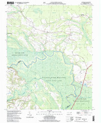
2002 Map of Quitsna
USGS Topo · Published 2002About this map
The Roanoke River dominates this landscape, winding through a complex of low-lying wetlands and islands along the border of Bertie and Martin Counties. The map reveals a river-centered economy and culture, evidenced by several historic river access points like Coniott Landing and Quitsna Landing. To the north, the small settlement of Quitsna serves as a hub, surrounded by a network of rural roads such as 1112 and 1108.
Find a feature on this map
39 named features on this map. Tap any name to fly to it.
Don’t see what you’re looking for? This feature index may not catch every label — zoom into the map to look around manually.
Map Details
Editions of this 2002 Quitsna Map
This is the sole edition of this map. No revisions or reprints were ever made.
Other maps of this area

1901 · Williamston
USGS Topo · 1:62,500

1902 · Williamston
USGS Topo · 1:62,500

1943 · Plymouth
USGS Topo · 1:125,000

1953 · Norfolk
USGS Topo · 1:250,000

1953 · Rocky Mount
USGS Topo · 1:250,000

1954 · Rocky Mount
USGS Topo · 1:250,000

1972 · Republican
USGS Topo · 1:24,000

1972 · Woodville
USGS Topo · 1:24,000
1978 · Jamesville
USGS Topo · 1:24,000

1978 · Windsor South
USGS Topo · 1:24,000