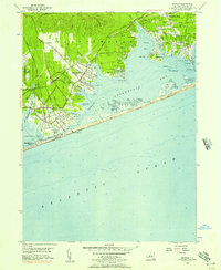
1956 Map of Quogue
USGS Topo · Published 1957About this map
The south shore of Long Island in the mid-1950s reveals a landscape defined by its coastal geography and early suburban development. Settlements such as Quogue and East Quogue are connected by the Long Island RR and Montauk Highway, showing a grid of residential streets expanding toward the water. To the north, the U.S. Military Reservation Suffolk County Air Force Base and the Quogue Waterfowl Refuge provide a contrast of industrial and natural land use. The map details the intricate shoreline of Shinnecock Bay, where Tiana Bay and various inlets like Penniman Cove meet the barrier beach. Marine navigation and recreation are central to the area's character, evidenced by the U.S. Coast Guard Sta near Ponquogue and the Yacht Club along Quogue Beach.
Find a feature on this map
53 named features on this map. Tap any name to fly to it.
Don’t see what you’re looking for? This feature index may not catch every label — zoom into the map to look around manually.
Map Details
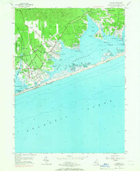
Editions of this 1956 Quogue Map
2 editions found
Other maps of this area

1903 · Sag Harbor
USGS Topo · 1:62,500

1903 · Riverhead
USGS Topo · 1:62,500

1904 · Sag Harbor
USGS Topo · 1:62,500

1904 · Riverhead
USGS Topo · 1:62,500

1943 · Riverhead
USGS Topo · 1:62,500

1947 · Mattituck
USGS Topo · 1:24,000

1947 · Southampton
USGS Topo · 1:24,000

1947 · Riverhead
USGS Topo · 1:24,000

1947 · Quogue
USGS Topo · 1:24,000

1947 · Eastport
USGS Topo · 1:24,000
Featured Places
- Southampton, NY
- Hampton Bays, Southampton
- East Quogue, Southampton
- Flanders, Southampton
- Westhampton, Southampton