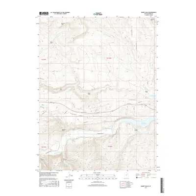
2017 Map of Rabbit Gulch
USGS Topo · Published 2017About this map
Strawberry River flows through the southern half of this Duchesne County landscape, feeding into the western reaches of Starvation Reservoir. The terrain is defined by dramatic elevation changes, where the high prominence of Blacktail Ridge overlooks a complex system of drainage features including Rabbit Gulch and Sink Draw. This 2017 survey details the intersection of modern rural development and topographical obstacles, showing a network of local access roads like Rainbow Rd and Hawkeye Ln that navigate the high plateaus and canyon floors. To the south, the map records the rugged descent into Skitzy Canyon and Lake Canyon, while providing a clear view of Lower Lake and the wetlands along the river corridor. The geography here is a stark example of the arid high-desert environment, where seasonal water features like Saleratus Wash and Blackburn Hollow shape the land between the ridges.
Find a feature on this map
34 named features on this map. Tap any name to fly to it.
Don’t see what you’re looking for? This feature index may not catch every label — zoom into the map to look around manually.
Map Details
Editions of this 2017 Rabbit Gulch Map
This is the sole edition of this map. No revisions or reprints were ever made.
Other maps of this area

1885 · Uinta
USGS Topo · 1:250,000

1939 · Duchesne
USGS Topo · 1:125,000

1954 · Salt Lake City
USGS Topo · 1:250,000

1958 · Salt Lake City
USGS Topo · 1:250,000

1960 · Salt Lake City
USGS Topo · 1:250,000

1962 · Strawberry Pinnacles
USGS Topo · 1:24,000
1962 · Buck Knoll
USGS Topo · 1:24,000
1962 · Sams Canyon
USGS Topo · 1:24,000

1962 · Blacktail Mtn
USGS Topo · 1:24,000

1962 · Tabiona
USGS Topo · 1:24,000