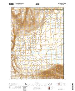
2020 Map of Rabbit Hills NW
USGS Topo · Published 2020About this map
Sherlock Gulch Reservoir marks the northeastern landscape of this portion of Harney County, sitting at the transition between the high desert plains and the rising terrain of the eastern Oregon interior. The sheet documents a vast, open expanse defined more by its drainage patterns and elevation shifts than by human settlements, reflecting a region where water management is central to the land's utility. Though the landscape appears sparse, the presence of the reservoir indicates the critical importance of seasonal water capture in an environment dominated by topographic contours and dry gulches. This survey provides a baseline of the high desert's geographic character in the early 21st century, detailing a remote section of the state where the natural terrain remains the primary feature.
Find a feature on this map
1 named feature on this map. Tap any name to fly to it.
Don’t see what you’re looking for? This feature index may not catch every label — zoom into the map to look around manually.
Map Details
Editions of this 2020 Rabbit Hills NW Map
This is the sole edition of this map. No revisions or reprints were ever made.
Other maps of this area

1955 · Klamath Falls
USGS Topo · 1:250,000

1955 · Adel
USGS Topo · 1:250,000

1957 · Adel
USGS Topo · 1:250,000

1958 · Klamath Falls
USGS Topo · 1:250,000

1958 · Adel
USGS Topo · 1:250,000

1962 · Adel
USGS Topo · 1:250,000

1966 · Rabbit Hills NE
USGS Topo · 1:24,000

1966 · Rabbit Hills NW
USGS Topo · 1:24,000

1967 · Flagstaff Lake
USGS Topo · 1:24,000

1967 · Rabbit Hills SW
USGS Topo · 1:24,000