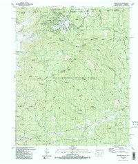
1988 Map of Rabun Bald
USGS Topo · Published 1988About this map
The Blue Ridge landscape along the North Carolina Georgia border is anchored by Sky Valley, a resort settlement situated among high peaks like Flat Top and Alex Mountain. As of 1988, this region near the eastern continental divide shows a mix of recreational development and deeply rooted mountain heritage. The map traces the winding paths of the Bartram Trail as it crosses from Rock Mtn toward the Chattahoochee National Forest.
Find a feature on this map
91 named features on this map. Tap any name to fly to it.
Don’t see what you’re looking for? This feature index may not catch every label — zoom into the map to look around manually.
Map Details
Editions of this 1988 Rabun Bald Map
2 editions found
Other maps of this area

1886 · Walhalla
USGS Topo · 1:125,000

1891 · Cowee
USGS Topo · 1:125,000

1892 · Walhalla
USGS Topo · 1:125,000

1896 · Walhalla
USGS Topo · 1:125,000

1897 · Cowee
USGS Topo · 1:125,000

1907 · Cowee
USGS Topo · 1:125,000

1935 · Prentiss
USGS Topo · 1:24,000

1935 · Dillard
USGS Topo · 1:24,000

1935 · Scaly
USGS Topo · 1:24,000

1935 · Rabun Bald
USGS Topo · 1:24,000