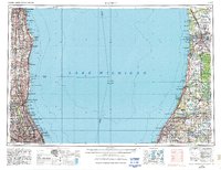
1962 Map of Racine
USGS Topo · Published 1962About this map
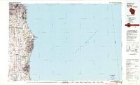
Lake Michigan dominates this mid-century survey, separating the industrial corridors of Wisconsin and Illinois from the orchards and dunes of southwestern Michigan. On the western shore, a continuous urban expansion stretches from Milwaukee down through Racine and Kenosha toward Chicago, where the transportation network is anchored by major hubs like General Mitchell Field and Glenview NAS. The military presence is particularly prominent along the coast, evidenced by the Great Lakes Naval Training Center and Fort Sheridan. Across the water, the Michigan coastline offers a distinct contrast, defined by the Van Buren Bluffs and a series of inland water bodies such as Paw Paw Lake and the Sister Lakes. This eastern portion of the map highlights a landscape of conservation and recreation, including the extensive Allegan State Forest and the Fennville State Game Area, illustrating the regional importance of the Kalamazoo River basin for both drainage and leisure during the post-war era.
Find a feature on this map
189 named features on this map. Tap any name to fly to it.
Don’t see what you’re looking for? This feature index may not catch every label — zoom into the map to look around manually.
Map Details
Editions of this 1962 Racine Map
This is the sole edition of this map. No revisions or reprints were ever made.
Historical Maps of Downtown Through Time
6 maps found