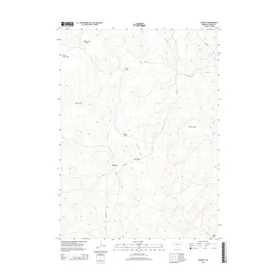
2014 Map of Rackett
USGS Topo · Published 2014About this map
Rackett and the surrounding Garden County sandhills landscape are defined by a complex network of dry valleys and elevated plateaus in this 2014 survey. The settlement itself sits at a junction where Rackett Rd meets Road 193, surrounded by expansive terrain features like Phillips Flats and Adams Flats. This region of Nebraska is characterized by its distinct topographical naming conventions, where lowland stretches are identified as named valleys, such as Wymore Valley and Bennett Valley, despite the absence of traditional river systems. The inclusion of Ward Lake provides a rare point of surface water in an area otherwise dominated by the undulating contours of the plains. Local historians can trace the transit corridors that connect these remote cattle-country outposts, including the path of Road 102 and the route toward Green Valley.
Find a feature on this map
16 named features on this map. Tap any name to fly to it.
Don’t see what you’re looking for? This feature index may not catch every label — zoom into the map to look around manually.
Map Details
Editions of this 2014 Rackett Map
This is the sole edition of this map. No revisions or reprints were ever made.
Other maps of this area

1949 · Mumper
USGS Topo · 1:62,500

1949 · Rackett
USGS Topo · 1:62,500

1950 · Crescent Lake
USGS Topo · 1:62,500

1950 · Longfellow Lake
USGS Topo · 1:62,500

1951 · Rackett
USGS Topo · 1:62,500

1954 · Scottsbluff
USGS Topo · 1:250,000

1958 · Scottsbluff
USGS Topo · 1:250,000

1985 · Crescent Lake
USGS Topo · 1:100,000
1986 · Gusher Spring
USGS Topo · 1:24,000
1986 · Hessey Lake
USGS Topo · 1:24,000