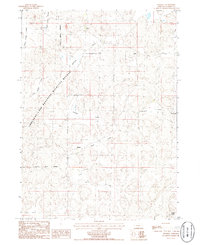
1986 Map of Rackett
USGS Topo · Published 1986About this map
Crescent Lake National Wildlife Refuge dominates the western portion of this landscape, its boundary cutting a diagonal line across the Sandhills terrain. The settlement of Rackett sits near the center, serving as a hub for the surrounding ranching country in the mid-1980s. The topography is defined by a series of distinct depressions and drainage basins, including Bennett Valley, Wymore Valley, and Gate Valley, which contrast with the level expanses of Adams Flats and Phillips Flats. Private landholdings like Jensen Ranch and Grace Ranch are interspersed with the protected refuge lands, illustrating the region's historical reliance on cattle grazing. Remote water features such as Ward Lake in the east and Upper Jones Valley in the northwest provide essential resources for both wildlife and livestock in this semi-arid environment.
Find a feature on this map
14 named features on this map. Tap any name to fly to it.
Don’t see what you’re looking for? This feature index may not catch every label — zoom into the map to look around manually.
Map Details
Editions of this 1986 Rackett Map
This is the sole edition of this map. No revisions or reprints were ever made.
Other maps of this area

1949 · Mumper
USGS Topo · 1:62,500

1949 · Rackett
USGS Topo · 1:62,500

1950 · Crescent Lake
USGS Topo · 1:62,500

1950 · Longfellow Lake
USGS Topo · 1:62,500

1951 · Rackett
USGS Topo · 1:62,500

1954 · Scottsbluff
USGS Topo · 1:250,000

1958 · Scottsbluff
USGS Topo · 1:250,000

1985 · Crescent Lake
USGS Topo · 1:100,000
1986 · Gusher Spring
USGS Topo · 1:24,000
1986 · Hessey Lake
USGS Topo · 1:24,000