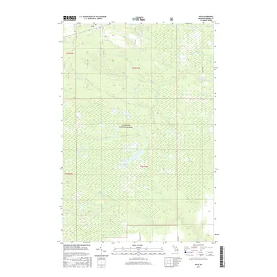
2017 Map of Raco
USGS Topo · Published 2017About this map
Raco sits in the northern reaches of the Hiawatha National Forest, serving as the primary human settlement in a landscape dominated by complex hydrology and forest management. This 2017 survey details the intricate drainage patterns of the Eastern Upper Peninsula, where the W Br Waiska River and the main Waiska River transition into a vast network of creeks and wetlands. Key water features such as the Sylvester Impoundment and Delirium Pond highlight the managed and natural aquatic environments that define the township. To the south, the terrain is marked by the N Pine River and Pine River, with numerous tributaries like Sylvester Cr and Bons Cr cutting through the woodland. The road network is sparse, consisting mainly of local routes like S Goldade Rd and W Sawyer Rd, which provide access to this heavily forested region of Chippewa County.
Find a feature on this map
23 named features on this map. Tap any name to fly to it.
Don’t see what you’re looking for? This feature index may not catch every label — zoom into the map to look around manually.
Map Details
Editions of this 2017 Raco Map
This is the sole edition of this map. No revisions or reprints were ever made.
Other maps of this area

1941 · Strongs
USGS Topo · 1:63,360

1941 · Brimley
USGS Topo · 1:63,360

1951 · Pendills Lake
USGS Topo · 1:24,000

1951 · Dollar Settlement
USGS Topo · 1:24,000

1951 · Sullivan Creek
USGS Topo · 1:24,000

1951 · Raco
USGS Topo · 1:24,000

1951 · Kinross
USGS Topo · 1:24,000

1951 · Brimley
USGS Topo · 1:62,500

1951 · Strongs
USGS Topo · 1:62,500

1951 · Brimley
USGS Topo · 1:24,000
Featured Places
- Kinross Township, MI
- Rudyard Township, MI
- Superior Township, MI
- Trout Lake Township, MI
- Chippewa County, MI