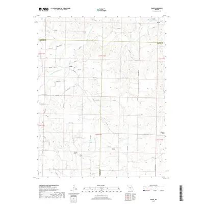
2017 Map of Rader
USGS Topo · Published 2017About this map
Rader and the small settlement of Pease sit at the center of this rural Ozark landscape, which is deeply carved by the Osage Fork Gasconade River and its various tributaries. The terrain is defined by a series of prominent hollows, including Phillips Hollow, Pender Hollow, and Rocky Hollow, illustrating the drainage patterns that shaped local development and road placement. Genealogists will find interest in the Weaver Cem and names like Chandler Hollow, reflecting the family histories of Laclede, Webster, and Wright counties. The area maintains a decidedly remote character, with transportation primarily limited to local routes such as State Hwy ZZ and Kilburn School Rd, following the natural contours of the river valleys and ridge lines.
Find a feature on this map
74 named features on this map. Tap any name to fly to it.
Don’t see what you’re looking for? This feature index may not catch every label — zoom into the map to look around manually.
Map Details
Editions of this 2017 Rader Map
This is the sole edition of this map. No revisions or reprints were ever made.
Other maps of this area

1939 · Long Lane
USGS Topo · 1:62,500

1941 · Lebanon
USGS Topo · 1:62,500

1942 · Long Lane
USGS Topo · 1:62,500

1943 · Lebanon
USGS Topo · 1:62,500

1946 · Niangua
USGS Topo · 1:62,500

1948 · Niangua
USGS Topo · 1:62,500

1954 · Springfield
USGS Topo · 1:250,000

1956 · Duncan
USGS Topo · 1:24,000

1956 · Rader
USGS Topo · 1:24,000
1956 · Hartville
USGS Topo · 1:24,000