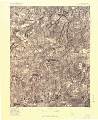
1977 Map of Rader
USGS Topo · Published 1977About this map
Rader serves as the focal point for this 1970s orthophotograph, a detailed aerial perspective produced in cooperation with the Soil Conservation Service. The landscape is defined by the winding course of the Osage Fork Gasconade River, which cuts through the northeastern and southwestern sections of the quadrangle. This aerial survey reveals the intricate patchwork of agricultural fields and timbered ridges characteristic of the Missouri Ozarks before modern development altered the rural footprint. By examining the vegetation patterns and field boundaries, researchers can distinguish between active pastures and woodlots, providing a clear record of land use and property divisions as they existed in the late twentieth century.
Find a feature on this map
2 named features on this map. Tap any name to fly to it.
Don’t see what you’re looking for? This feature index may not catch every label — zoom into the map to look around manually.
Map Details
Editions of this 1977 Rader Map
This is the sole edition of this map. No revisions or reprints were ever made.
Other maps of this area

1939 · Long Lane
USGS Topo · 1:62,500

1941 · Lebanon
USGS Topo · 1:62,500

1942 · Long Lane
USGS Topo · 1:62,500

1943 · Lebanon
USGS Topo · 1:62,500

1946 · Niangua
USGS Topo · 1:62,500

1948 · Niangua
USGS Topo · 1:62,500

1954 · Springfield
USGS Topo · 1:250,000

1956 · Duncan
USGS Topo · 1:24,000

1956 · Rader
USGS Topo · 1:24,000
1956 · Hartville
USGS Topo · 1:24,000