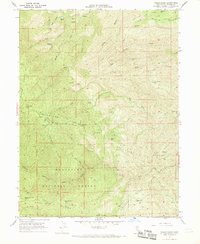
1967 Map of Raglin Ridge
USGS Topo · Published 1969About this map
Mendocino National Forest dominates this section of the inner Coast Range, where a network of trails and ridges defines the remote landscape. The map captures a moment in the late 1960s when small homesteads and clearings such as Hammer Place, Mary Ellen Place, and Connie Place persisted along the steep drainage divides. These named places, alongside flats like Wakefield Flat and Secret Flat, suggest a history of seasonal grazing or early settlement tucked into the high country.
Find a feature on this map
54 named features on this map. Tap any name to fly to it.
Don’t see what you’re looking for? This feature index may not catch every label — zoom into the map to look around manually.
Map Details
Editions of this 1967 Raglin Ridge Map
2 editions found
Other maps of this area

1890 · Red Bluff
USGS Topo · 1:250,000

1894 · Red Bluff
USGS Topo · 1:250,000

1949 · Colyear Springs
USGS Topo · 1:62,500

1952 · Paskenta
USGS Topo · 1:62,500

1952 · Anthony Peak
USGS Topo · 1:62,500

1954 · Yolla Bolly
USGS Topo · 1:62,500

1957 · Colyear Springs
USGS Topo · 1:62,500

1957 · Ukiah
USGS Topo · 1:250,000

1958 · Redding
USGS Topo · 1:250,000

1960 · Ukiah
USGS Topo · 1:250,000