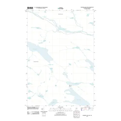
2011 Map of Rainbow Lake East
USGS Topo · Published 2011About this map
The West Branch Penobscot River carves a dramatic path through the northern landscape of this Maine wilderness, defining a territory marked by significant waterfalls and remote waterways. Significant hydrological features like Big Niagara Falls, Little Niagara Falls, and the complex Nesowadnehunk Deadwater illustrate the natural power of the river system before it reaches the Toll Dam. To the south, the expansive Rainbow Lake sits in the shadow of Rainbow Mountain, surrounded by a dense network of smaller bodies of water such as Doughnut Pond and Little Beaver Pond. The terrain is anchored by the presence of Sentinel Mountain, overlooking a region primarily shaped by logging history and natural preservation. These maps provide a clear view of the drainage patterns from Nesowadnehunk Stream to Stratton Brook, essential for understanding the historical movement of timber and the geographical isolation of the Maine woods.
Find a feature on this map
42 named features on this map. Tap any name to fly to it.
Don’t see what you’re looking for? This feature index may not catch every label — zoom into the map to look around manually.
Map Details
Editions of this 2011 Rainbow Lake East Map
This is the sole edition of this map. No revisions or reprints were ever made.
Other maps of this area

1927 · Katahdin
USGS Topo · 1:48,000

1930 · Katahdin
USGS Topo · 1:62,500

1949 · Katahdin
USGS Topo · 1:62,500

1951 · Norcross
USGS Topo · 1:62,500

1952 · Jo-Mary Mountain
USGS Topo · 1:62,500

1954 · Harrington Lake
USGS Topo · 1:62,500

1954 · Millinocket
USGS Topo · 1:250,000

1958 · Millinocket
USGS Topo · 1:250,000

1960 · Millinocket
USGS Topo · 1:250,000
1978 · Rainbow Lake West
USGS Topo · 1:24,000