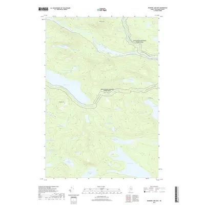
2018 Map of Rainbow Lake East
USGS Topo · Published 2018About this map
The West Branch Penobscot River cuts through this portion of Piscataquis County, defined by its series of significant river features like Little Ambejackmockamus Falls and Big Ambejackmockamus Falls. The landscape is dominated by a complex network of glacial water bodies, including Rainbow Lake and the sequential series of Second Debsconeag Lake, Fourth Debsconeag Lake, and Fifth Debsconeag Lake. This wilderness area is traversed by the Appalachian National Scenic Trail, which winds past Rainbow Mtn and Daisey Pond. The map illustrates a region where transportation is limited to rugged paths and the remote Hurd Pond Rd, emphasizing the area's role as a high-elevation recreational and conservation corridor. Notable terrain features like Sentinel Mtn provide the backdrop for numerous smaller ponds such as Clifford Pond and Stink Pond.
Find a feature on this map
43 named features on this map. Tap any name to fly to it.
Don’t see what you’re looking for? This feature index may not catch every label — zoom into the map to look around manually.
Map Details
Editions of this 2018 Rainbow Lake East Map
This is the sole edition of this map. No revisions or reprints were ever made.
Other maps of this area

1927 · Katahdin
USGS Topo · 1:48,000

1930 · Katahdin
USGS Topo · 1:62,500

1949 · Katahdin
USGS Topo · 1:62,500

1951 · Norcross
USGS Topo · 1:62,500

1952 · Jo-Mary Mountain
USGS Topo · 1:62,500

1954 · Harrington Lake
USGS Topo · 1:62,500

1954 · Millinocket
USGS Topo · 1:250,000

1958 · Millinocket
USGS Topo · 1:250,000

1960 · Millinocket
USGS Topo · 1:250,000
1978 · Rainbow Lake West
USGS Topo · 1:24,000