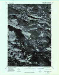
1978 Map of Rainbow Lake East
USGS Topo · Published 1981About this map
The West Branch Penobscot River winds through the northern reaches of this Maine landscape, captured in a late 1970s orthophotoquad. This aerial perspective emphasizes the dense forest cover and complex hydrological network of the region, where Rainbow Lake dominates the central terrain. To the south and east, a chain of glacial waters includes First Debsconeag Lake, Third Debsconeag Lake, and Fifth Debsconeag Lake. The imagery reveals the varied timber patterns and landforms, anchored by prominent elevations such as Sentinel Mountain and Rainbow Mountain. Unlike traditional topographic maps, this photographic study provides a direct view of the wilderness as it appeared during the 1978 survey, highlighting the confluence of Nesowadnehunk Stream and the primary river system.
Find a feature on this map
9 named features on this map. Tap any name to fly to it.
Don’t see what you’re looking for? This feature index may not catch every label — zoom into the map to look around manually.
Map Details
Editions of this 1978 Rainbow Lake East Map
This is the sole edition of this map. No revisions or reprints were ever made.
Other maps of this area

1927 · Katahdin
USGS Topo · 1:48,000

1930 · Katahdin
USGS Topo · 1:62,500

1949 · Katahdin
USGS Topo · 1:62,500

1951 · Norcross
USGS Topo · 1:62,500

1952 · Jo-Mary Mountain
USGS Topo · 1:62,500

1954 · Harrington Lake
USGS Topo · 1:62,500

1954 · Millinocket
USGS Topo · 1:250,000

1958 · Millinocket
USGS Topo · 1:250,000

1960 · Millinocket
USGS Topo · 1:250,000
1978 · Rainbow Lake West
USGS Topo · 1:24,000