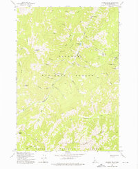
1973 Map of Rainbow Peak
USGS Topo · Published 1975About this map
Dewey Mine and the Sunnyside Mine define the high-altitude industrial activity of this mountain landscape within the Payette National Forest. This 1970s survey captures the remnants of a significant mining era, including the Twentieth Century Mill (Site) and scattered prospects along the steep drainages of Coon Creek and Cornish Creek. The terrain is marked by sharp peaks like Thunder Mtn and Lightning Peak, while the northern portion of the map includes Roosevelt Lake and a small Cem near Fall Creek, providing a point of interest for genealogists and local historians. The presence of numerous mining landmarks, including several U.S. Location Monuments like Uslm 4 and Uslm 5, indicates the heavy surveying required to manage claims across Gold Ridge and the Monumental Creek canyon.
Find a feature on this map
44 named features on this map. Tap any name to fly to it.
Don’t see what you’re looking for? This feature index may not catch every label — zoom into the map to look around manually.
Map Details
Editions of this 1973 Rainbow Peak Map
This is the sole edition of this map. No revisions or reprints were ever made.
Other maps of this area

1937 · Yellow Pine
USGS Topo · 1:48,000

1937 · Big Creek
USGS Topo · 1:48,000

1942 · Big Creek
USGS Topo · 1:62,500

1943 · Yellow Pine
USGS Topo · 1:62,500

1956 · Elk City
USGS Topo · 1:250,000

1957 · Challis
USGS Topo · 1:250,000

1960 · Elk City
USGS Topo · 1:250,000

1960 · Challis
USGS Topo · 1:250,000

1963 · Challis
USGS Topo · 1:250,000

1969 · Edwardsburg
USGS Topo · 1:24,000