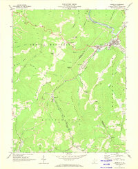
1969 Map of Rainelle
USGS Topo · Published 1973About this map
Meadow River defines the industrial and geographical heart of this West Virginia landscape, where the town of Rainelle serves as a central hub at the convergence of several mountain streams. In the late 1960s, the region was characterized by a heavy reliance on the Sewell and NF&G railroads, which facilitated the transport of resources from numerous strip mines and deeper mines dotting the slopes of Sewell Mountain and Quinnimont Mountain.
Find a feature on this map
58 named features on this map. Tap any name to fly to it.
Don’t see what you’re looking for? This feature index may not catch every label — zoom into the map to look around manually.
Map Details
Editions of this 1969 Rainelle Map
2 editions found
Other maps of this area

1887 · Hinton
USGS Topo · 1:125,000

1889 · Nicholas
USGS Topo · 1:125,000

1891 · Nicholas
USGS Topo · 1:125,000

1892 · Hinton
USGS Topo · 1:125,000

1901 · Nicholas
USGS Topo · 1:125,000

1912 · Meadow Creek
USGS Topo · 1:48,000

1914 · Winona
USGS Topo · 1:48,000

1915 · Meadow Creek
USGS Topo · 1:62,500

1916 · Winona
USGS Topo · 1:62,500

1918 · Richwood
USGS Topo · 1:62,500