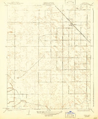
1925 Map of Raisin
USGS Topo · Published 1942About this map
The settlement of Raisin serves as the focal point of this Fresno County survey, situated at the intersection of a massive grid of agricultural roadways and the Southern Pacific railroad line. Surveyed in the early 1920s, the landscape reveals the organized development of California's Central Valley, where long, straight thoroughfares like Manning Avenue and Floral Avenue partition the land into productive blocks. The map captures the infrastructure supporting this expansion, including the prominent transmission lines of the San Joaquin and Light and Power Corporation and the essential irrigation provided by the Liberty Ditch. The terrain is characterized by intricate contouring that suggests the subtle shifts in elevation across the valley floor, essential for managing water flow through canals and ditches in this intensive agricultural region.
Find a feature on this map
24 named features on this map. Tap any name to fly to it.
Don’t see what you’re looking for? This feature index may not catch every label — zoom into the map to look around manually.
Map Details
Editions of this 1925 Raisin Map
2 editions found
Other maps of this area

1912 · Coalinga
USGS Topo · 1:125,000

1923 · Kearney Park
USGS Topo · 1:31,680

1923 · Fresno
USGS Topo · 1:31,680

1924 · Riverdale
USGS Topo · 1:31,680

1925 · Helm
USGS Topo · 1:31,680

1925 · Raisin
USGS Topo · 1:31,680

1925 · Caruthers
USGS Topo · 1:31,680

1927 · Burrel
USGS Topo · 1:31,680

1927 · Riverdale
USGS Topo · 1:31,680

1931 · Wheatville
USGS Topo · 1:31,680