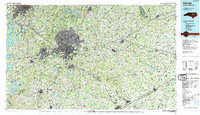
1990 Map of Raleigh
USGS Topo · Published 1991About this map
The capital city of Raleigh anchors this 1990 survey, showing the rapid expansion of the Research Triangle as residential and industrial centers like Cary, Garner, and Morrisville grow toward one another. The landscape is defined by its massive water projects and state-managed lands, including the extensive shorelines of Everett Jordan Lake and Falls Lake State Park. Large-scale infrastructure is prominent, from the State Prison complex to the sprawling Harris Reservoir.
Find a feature on this map
89 named features on this map. Tap any name to fly to it.
Don’t see what you’re looking for? This feature index may not catch every label — zoom into the map to look around manually.
Map Details
Editions of this 1990 Raleigh Map
2 editions found
Other maps of this area

1902 · Kenly
USGS Topo · 1:62,500

1902 · Rocky Mount
USGS Topo · 1:62,500

1902 · Spring Hope
USGS Topo · 1:62,500

1903 · Kenly
USGS Topo · 1:62,500

1904 · Rocky Mount
USGS Topo · 1:62,500

1904 · Springhope
USGS Topo · 1:62,500

1904 · Wilson
USGS Topo · 1:62,500

1906 · Four Oaks
USGS Topo · 1:48,000

1908 · Four Oaks
USGS Topo · 1:62,500

1943 · Durham South
USGS Topo · 1:62,500