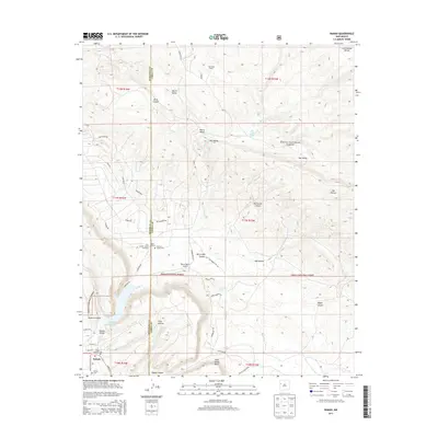
2013 Map of Ramah
USGS Topo · Published 2013About this map
Continental Divide crests along the northeastern corner of this landscape, where the high desert terrain of the Cibola National Forest drops into deep sandstone drainages. The village of Ramah serves as the primary settlement, situated in the fertile Ramah Valley near the Ramah Reservoir. This area reflects a long history of ranching and settlement, evidenced by the Old Bond Ranch and the Mormon Colony Cem, which marks the legacy of early pioneers in the region. The map highlights a transition from open valleys like Harris Valley and Dan Valley to the dramatic vertical relief of Wild Sheep Mesa and Burnt Mill Canyon. Transportation is defined by a network of local roads including Timberlake Rd and Indian Service Route 132, while the Mystic Bluffs Airport provides a modern connection to this high-altitude cattle and farming country.
Find a feature on this map
54 named features on this map. Tap any name to fly to it.
Don’t see what you’re looking for? This feature index may not catch every label — zoom into the map to look around manually.
Map Details
Editions of this 2013 Ramah Map
This is the sole edition of this map. No revisions or reprints were ever made.
Other maps of this area

1886 · Wingate
USGS Topo · 1:250,000

1892 · Wingate
USGS Topo · 1:250,000

1954 · Gallup
USGS Topo · 1:250,000

1958 · Gallup
USGS Topo · 1:250,000

1959 · Gallup
USGS Topo · 1:250,000

1961 · Cottonwood Canyon
USGS Topo · 1:24,000

1962 · Gallup
USGS Topo · 1:250,000

1962 · Cottonwood Canyon
USGS Topo · 1:24,000

1962 · Page
USGS Topo · 1:24,000
1963 · Togeye Lake
USGS Topo · 1:24,000
Featured Places
- Eastern Navajo Agency, NM
- Ramah, Eastern Navajo Agency
- McKinley County, NM
- Cibola County, NM
- United States