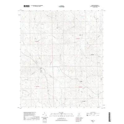
2018 Map of Ramer
USGS Topo · Published 2018About this map
The settlement of Ramer serves as a focal point in this southern Montgomery County landscape, where the local road network fans out into the surrounding countryside. This survey captures a rural environment defined by its watercourses, including Patsaliga Cr, Weaver Mill Cr, and Ramer Cr, which have historically shaped the agricultural and social layout of the region. The map reveals a high density of named family landmarks and cemeteries, such as Chesser Cem and Sentell Cem, providing essential geographic context for genealogists tracking lineages in the townships of t13n r18e and t13n r19e. Smaller communities like Dublin, Gibson, and Meadville are interconnected by historically significant routes like Smiley Ferry RD and Lower Dublin RD, illustrating the enduring spatial relationships of these small Alabama crossroads.
Find a feature on this map
58 named features on this map. Tap any name to fly to it.
Don’t see what you’re looking for? This feature index may not catch every label — zoom into the map to look around manually.
Map Details
Editions of this 2018 Ramer Map
This is the sole edition of this map. No revisions or reprints were ever made.
Other maps of this area

1953 · Montgomery
USGS Topo · 1:250,000

1953 · Andalusia
USGS Topo · 1:250,000

1956 · Montgomery
USGS Topo · 1:250,000

1957 · Montgomery
USGS Topo · 1:250,000

1957 · Andalusia
USGS Topo · 1:250,000

1957 · Letohatchee
USGS Topo · 1:62,500
1968 · Ansley
USGS Topo · 1:24,000

1968 · Grady
USGS Topo · 1:24,000

1971 · Davis Crossroads
USGS Topo · 1:24,000
1971 · Teasleys Mill
USGS Topo · 1:24,000