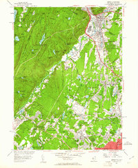
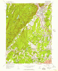
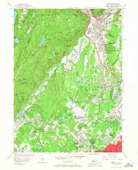
1955 Map of Ramsey
USGS Topo · Published 1961About this map
The Ramapo Mountains dominate the western half of this Bergen County survey, where the peaks of Bald Mtn and Houvenkopf Mountain overlook a complex network of recreational camps and reservoirs. Deep in the hills, Bear Swamp Lake and MacMillan Reservoir sit within the drainage of the Ramapo River, which cuts a corridor for the Erie RR and the Thruway through Mahwah and Suffern. This mid-century landscape is defined by its transition from the wooded heights of Campgaw Mountain to the burgeoning residential grids of Ramsey, Allendale, and Waldwick in the east.
Find a feature on this map
133 named features on this map. Tap any name to fly to it.
Don’t see what you’re looking for? This feature index may not catch every label — zoom into the map to look around manually.
Map Details
Editions of this 1955 Ramsey Map
Other maps of this area

1888 · Morristown
USGS Topo · 1:62,500

1888 · Paterson
USGS Topo · 1:62,500

1891 · Greenwood Lake
USGS Topo · 1:62,500

1891 · Ramapo
USGS Topo · 1:62,500

1892 · Paterson
USGS Topo · 1:62,500

1893 · Greenwood Lake
USGS Topo · 1:62,500

1893 · Ramapo
USGS Topo · 1:62,500

1894 · Morristown
USGS Topo · 1:62,500

1898 · Morristown
USGS Topo · 1:62,500

1898 · Paterson
USGS Topo · 1:62,500