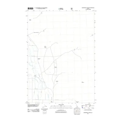
2011 Map of Ramshorn Canyon
USGS Topo · Published 2011About this map
The Big Lost River corridor in Custer County defines this landscape, revealing a complex network of early 21st-century water management infrastructure designed for high-altitude valley agriculture. The presence of the Moore Diversion and associated waterways like Moore Canal, Burnett Ditch, and Island Ditch illustrates the vital importance of irrigation in this arid environment. To the east, the topography rises sharply toward the massif of King Mountain, a dominant landmark reached via the crossing at Beaverland Pass. The map traces a series of dramatic drainages including Ramshorn Canyon, Big Burnett Canyon, and Limekiln Canyon, which cut westward from the high peaks toward the valley floor. Small-scale rural transit is marked by local connectors such as Darlington Ln and King Canyon Rd, which tie the scattered ranching and agricultural interests to the primary water sources like Big Spring.
Find a feature on this map
24 named features on this map. Tap any name to fly to it.
Don’t see what you’re looking for? This feature index may not catch every label — zoom into the map to look around manually.
Map Details
Editions of this 2011 Ramshorn Canyon Map
This is the sole edition of this map. No revisions or reprints were ever made.
Other maps of this area

1955 · Idaho Falls
USGS Topo · 1:250,000

1958 · Idaho Falls
USGS Topo · 1:250,000

1969 · Darlington
USGS Topo · 1:24,000

1969 · Arco Pass
USGS Topo · 1:24,000

1969 · Ramshorn Canyon
USGS Topo · 1:24,000

1969 · Howe NW
USGS Topo · 1:24,000

1969 · Sunset Peak
USGS Topo · 1:24,000
1969 · Methodist Creek
USGS Topo · 1:24,000

1972 · Arco North
USGS Topo · 1:24,000

1972 · Arco Hills
USGS Topo · 1:24,000