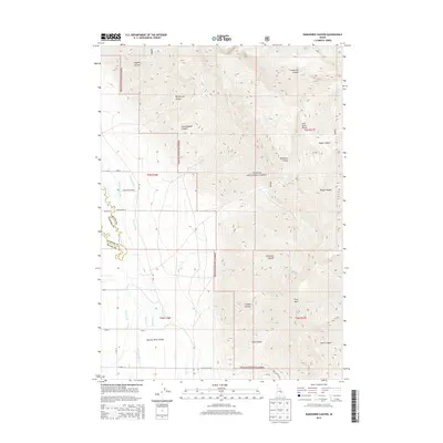
2013 Map of Ramshorn Canyon
USGS Topo · Published 2013About this map
Challis National Forest dominates the high-elevation terrain of the Lost River Range, where deep drainages like Ramshorn Canyon and Big Burnett Canyon cut through the steep slopes. This 2013 survey illustrates the complex water management system required for life in the Big Lost River Valley below. A network of hand-named water features, including Burnett Ditch, the Moore Canal, and the Beck and Evan Ditch, divert flow from the Big Lost River to support agricultural parcels at the mountain base. In the south, King Mtn stands as a prominent landmark near Hurst Canyon, overlooking a transition from the forest's protected peaks to the organized road grids of Syveria Ln and McAfee Ln. The map documents the persistent human engineering required to channel the Spring Cr and other alpine waters across the Idaho landscape.
Find a feature on this map
36 named features on this map. Tap any name to fly to it.
Don’t see what you’re looking for? This feature index may not catch every label — zoom into the map to look around manually.
Map Details
Editions of this 2013 Ramshorn Canyon Map
This is the sole edition of this map. No revisions or reprints were ever made.
Other maps of this area

1955 · Idaho Falls
USGS Topo · 1:250,000

1958 · Idaho Falls
USGS Topo · 1:250,000

1969 · Darlington
USGS Topo · 1:24,000

1969 · Arco Pass
USGS Topo · 1:24,000

1969 · Ramshorn Canyon
USGS Topo · 1:24,000

1969 · Howe NW
USGS Topo · 1:24,000

1969 · Sunset Peak
USGS Topo · 1:24,000
1969 · Methodist Creek
USGS Topo · 1:24,000

1972 · Arco North
USGS Topo · 1:24,000

1972 · Arco Hills
USGS Topo · 1:24,000