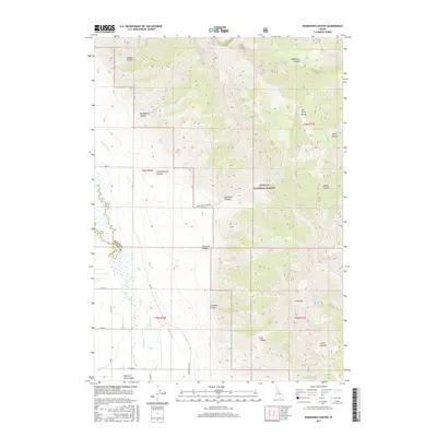
2017 Map of Ramshorn Canyon
USGS Topo · Published 2017About this map
Challis National Forest dominates the rugged upper elevations of this terrain, where the Lost River Range rises sharply above the agricultural lowlands. The landscape transitions from steep peaks like King Mtn and deep incisions such as Ramshorn Canyon to the wide expanse of the Big Lost River Valley. This valley floor reveals an intricate network of water management essential for high-altitude ranching and farming, featuring engineered waterways like the Burnett Ditch, Island Ditch, and Moore Canal. These structures, alongside the Big Lost River and smaller tributaries like Spring Cr, illustrate the historical reliance on irrigation to sustain settlement in the arid shadows of Idaho's high peaks. Modern access is marked by rural thoroughfares including King Mountain Rd and Hill Rd, connecting the scattered homesteads and canyon mouths to the broader region.
Find a feature on this map
37 named features on this map. Tap any name to fly to it.
Don’t see what you’re looking for? This feature index may not catch every label — zoom into the map to look around manually.
Map Details
Editions of this 2017 Ramshorn Canyon Map
This is the sole edition of this map. No revisions or reprints were ever made.
Other maps of this area

1955 · Idaho Falls
USGS Topo · 1:250,000

1958 · Idaho Falls
USGS Topo · 1:250,000

1969 · Darlington
USGS Topo · 1:24,000

1969 · Arco Pass
USGS Topo · 1:24,000

1969 · Ramshorn Canyon
USGS Topo · 1:24,000

1969 · Howe NW
USGS Topo · 1:24,000

1969 · Sunset Peak
USGS Topo · 1:24,000
1969 · Methodist Creek
USGS Topo · 1:24,000

1972 · Arco North
USGS Topo · 1:24,000

1972 · Arco Hills
USGS Topo · 1:24,000