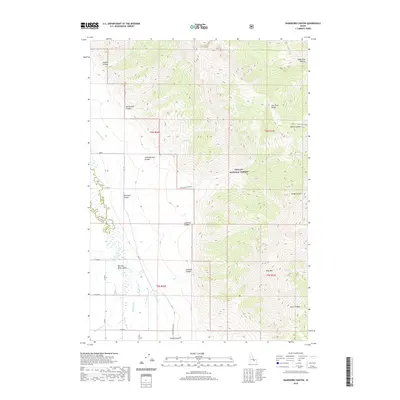
2020 Map of Ramshorn Canyon
USGS Topo · Published 2020About this map
The Lost River Range dominates this landscape, where steep topography transitions into the agricultural reaches of the Big Lost River Valley. This 2020 survey illustrates the complex water management system essential to the region, featuring infrastructure such as Island Ditch, Burnett Ditch, and the Moore Canal that divert water from the Big Lost River. The map captures the interface between the protected wilderness of the Challis National Forest and the surveyed township lines of t6n r26e and t5n r27e.
Find a feature on this map
29 named features on this map. Tap any name to fly to it.
Don’t see what you’re looking for? This feature index may not catch every label — zoom into the map to look around manually.
Map Details
Editions of this 2020 Ramshorn Canyon Map
This is the sole edition of this map. No revisions or reprints were ever made.
Other maps of this area

1955 · Idaho Falls
USGS Topo · 1:250,000

1958 · Idaho Falls
USGS Topo · 1:250,000

1969 · Darlington
USGS Topo · 1:24,000

1969 · Arco Pass
USGS Topo · 1:24,000

1969 · Ramshorn Canyon
USGS Topo · 1:24,000

1969 · Howe NW
USGS Topo · 1:24,000

1969 · Sunset Peak
USGS Topo · 1:24,000
1969 · Methodist Creek
USGS Topo · 1:24,000

1972 · Arco North
USGS Topo · 1:24,000

1972 · Arco Hills
USGS Topo · 1:24,000