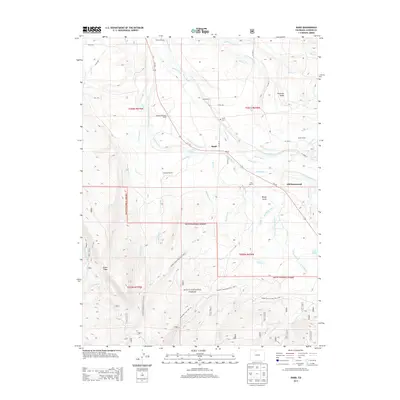
2013 Map of Rand
USGS Topo · Published 2013About this map
The small settlement of Rand serves as the focal point of this northern Colorado ranching landscape, situated along the Illinois River where several mountain streams and irrigation ditches converge. This high-altitude valley is defined by its extensive system of water management, evidenced by named features like the Monroe Ditch and John S Sutton Ditch that feed the local ranchlands. Family heritage is deeply embedded in the geography here, with numerous sites such as the Stephens Brothers Ranch, Fuqua Ranch, and Donelson Ranch marking the valley floor. To the south and west, the terrain rises into the Routt National Forest, where the Snyder Creek Loop Trail 1226.1 and Sidewinder Trail 1226.1A wind through the timber. Notable landmarks for local history include the Rand Cem and the former location of the Old Homestead near the eastern edge of the survey.
Find a feature on this map
63 named features on this map. Tap any name to fly to it.
Don’t see what you’re looking for? This feature index may not catch every label — zoom into the map to look around manually.
Map Details
Editions of this 2013 Rand Map
This is the sole edition of this map. No revisions or reprints were ever made.
Other maps of this area

1954 · Craig
USGS Topo · 1:250,000

1955 · Gould
USGS Topo · 1:24,000

1955 · Owl Ridge
USGS Topo · 1:24,000

1955 · Mac Farlane Reservoir
USGS Topo · 1:24,000

1955 · Walden
USGS Topo · 1:62,500

1956 · Radial Mountain
USGS Topo · 1:24,000

1956 · Jack Creek Ranch
USGS Topo · 1:24,000

1956 · Parkview Mountain
USGS Topo · 1:24,000

1956 · Buffalo Peak
USGS Topo · 1:24,000

1956 · Hyannis Peak
USGS Topo · 1:24,000