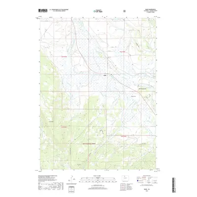
2019 Map of Rand
USGS Topo · Published 2019About this map
Rand sits as a central hub for the irrigation networks of Jackson County, where the Illinois River is diverted through an extensive system of named watercourses. The landscape is defined by the agricultural management of water, evidenced by the Welch-and-Peabody Ditch, Hanover Ditch, and John S Sutton Ditch. To the south, the terrain rises into the timbered elevations of the Routt National Forest, marked by landmarks like Green Ridge and Windy Point. This area reflects a long-standing ranching tradition, with the Old Homestead and Rand Cemetery serving as primary points for genealogical interest. The map detail extends to high-country features such as Lake Ruby and recreational trails like the Snyder Creek Loop and Sidewinder, illustrating the intersection of industrial water rights and public forest lands.
Find a feature on this map
60 named features on this map. Tap any name to fly to it.
Don’t see what you’re looking for? This feature index may not catch every label — zoom into the map to look around manually.
Map Details
Editions of this 2019 Rand Map
This is the sole edition of this map. No revisions or reprints were ever made.
Other maps of this area

1954 · Craig
USGS Topo · 1:250,000

1955 · Gould
USGS Topo · 1:24,000

1955 · Owl Ridge
USGS Topo · 1:24,000

1955 · Mac Farlane Reservoir
USGS Topo · 1:24,000

1955 · Walden
USGS Topo · 1:62,500

1956 · Radial Mountain
USGS Topo · 1:24,000

1956 · Jack Creek Ranch
USGS Topo · 1:24,000

1956 · Parkview Mountain
USGS Topo · 1:24,000

1956 · Buffalo Peak
USGS Topo · 1:24,000

1956 · Hyannis Peak
USGS Topo · 1:24,000