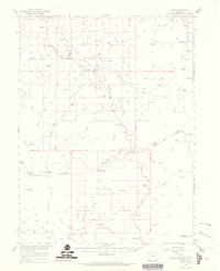
1956 Map of Rand
USGS Topo · Published 1969About this map
High mountain valleys and ranching outposts define this 1956 mid-century landscape along the Jackson and Grand County line. The Illinois River flows through a complex network of irrigation channels, including the Peabody Ditch, Welch Ditch, and Garland Ditch, which support the scattered ranching operations that anchor the local economy. Small settlements and family holdings like Rand, Old Homestead, and Howard Ranch are connected by improved roads and primitive tracks that wind toward the Continental Divide.
Find a feature on this map
98 named features on this map. Tap any name to fly to it.
Don’t see what you’re looking for? This feature index may not catch every label — zoom into the map to look around manually.
Map Details
Editions of this 1956 Rand Map
3 editions found

Other maps of this area

1915 · Longs Peak
USGS Topo · 1:125,000

1916 · Home
USGS Topo · 1:125,000

1919 · Rocky Mountain National Park
USGS Topo · 1:125,000

1920 · Home
USGS Topo · 1:125,000

1954 · Greeley
USGS Topo · 1:250,000

1954 · Craig
USGS Topo · 1:250,000

1955 · Gould
USGS Topo · 1:24,000

1955 · Owl Ridge
USGS Topo · 1:24,000

1955 · Mac Farlane Reservoir
USGS Topo · 1:24,000

1955 · Walden
USGS Topo · 1:62,500