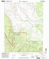
2000 Map of Rand
USGS Topo · Published 2004About this map
The Illinois River valley serves as the central artery for this high-altitude ranching community at the turn of the millennium. The settlement of Rand anchors the landscape, supported by essential local institutions like the Rand Sch and the Rand Cem. This area is defined by an extensive and sophisticated irrigation network designed to support livestock and agriculture in a semi-arid mountain environment, including the Ottawa Ditch, Peabody Ditch, and Hanover DITCH. Numerous family holdings are established along the watercourses, such as the Stephens Brothers Ranch, Fugua Ranch, and Hills Ranch. To the south, the terrain rises sharply into the timbered slopes of the Routt National Forest near Green Ridge, while high-country water features like Lake Ruby and the East Branch of the Illinois River dominate the southeastern reaches of the survey.
Find a feature on this map
45 named features on this map. Tap any name to fly to it.
Don’t see what you’re looking for? This feature index may not catch every label — zoom into the map to look around manually.
Map Details
Editions of this 2000 Rand Map
This is the sole edition of this map. No revisions or reprints were ever made.
Other maps of this area

1954 · Craig
USGS Topo · 1:250,000

1955 · Gould
USGS Topo · 1:24,000

1955 · Owl Ridge
USGS Topo · 1:24,000

1955 · Mac Farlane Reservoir
USGS Topo · 1:24,000

1955 · Walden
USGS Topo · 1:62,500

1956 · Radial Mountain
USGS Topo · 1:24,000

1956 · Jack Creek Ranch
USGS Topo · 1:24,000

1956 · Parkview Mountain
USGS Topo · 1:24,000

1956 · Buffalo Peak
USGS Topo · 1:24,000

1956 · Hyannis Peak
USGS Topo · 1:24,000