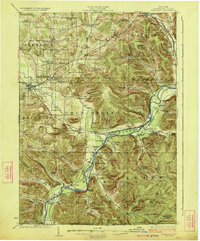
1923 Map of Randolph
USGS Topo · Published 1923About this map
The Allegany Indian Reservation follows the winding course of the Allegheny River through this 1922 survey of Cattaraugus County. The region is defined by a dense network of rural infrastructure, including numerous educational sites like the Friends Indian School and Indian School No 1. To the east, the newly established Allegany State Park encompasses several peaks named for indigenous nations, such as Mt Onondaga and Mt Seneca.
Find a feature on this map
95 named features on this map. Tap any name to fly to it.
Don’t see what you’re looking for? This feature index may not catch every label — zoom into the map to look around manually.
Map Details
Editions of this 1923 Randolph Map
4 editions found
Other maps of this area

1900 · Cherry Creek
USGS Topo · 1:62,500

1900 · Salamanca
USGS Topo · 1:62,500

1905 · Jamestown
USGS Topo · 1:62,500

1906 · Warren
USGS Topo · 1:62,500

1907 · Warren
USGS Topo · 1:62,500

1908 · Warren
USGS Topo · 1:62,500

1922 · Randolph
USGS Topo · 1:62,500

1923 · Randolph
USGS Topo · 1:62,500

1923 · Cattaraugus
USGS Topo · 1:62,500

1924 · Ellicottville
USGS Topo · 1:62,500